State Highway 5 (SH5) between Napier and Taupō suffered significant damaged caused by Cyclone Gabrielle in February 2023. The Transport Rebuild East Coast (TREC) Alliance is delivering recovery work to restore this road back to how it was and keep communities connected.
We’ve made steady progress on restoring SH5. Most of the damage here was from underslips and damaged culverts (which channel and drain water away from the road). Much of the recovery work has been happening out of sight below the road.
SH5 Recovery projects map

TREC has completed repairs at a number of recovery sites and delivered safety improvements alongside them.
Pokopoko Gully
Work has been completed on constructing on an asphalt bund (an embankment) to channel stormwater to riprap (large stones/rock) on the valley floor.

Stoney Creek underslip
We have repaired a 7m underslip at Stoney Creek with buttress rocks to support and strengthen the wall, a water channel to remove surface water, and large rock (riprap) protection.

Captain’s Culvert
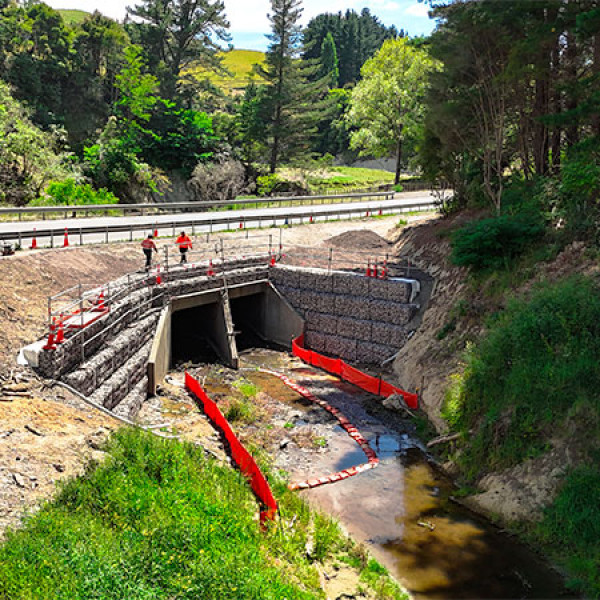
After Cyclone Gabrielle, Captain’s Culvert was clogged with debris and silt. A blocked culvert can damage roads and create safety issues for drivers, potentially leading to highway closures.
The repairs will help prevent future damage and closures by slowing water flow during heavy rain, protecting the stream’s walls from erosion, and ensuring the culvert works properly.
What you couldn’t see from the road was marine life being relocated and the stream temporarily diverted while a dam-like structure was been built to slow water flow in heavy rain.
This large box style culvert was severely damaged including to the bracing, joints, road surface, handrail and guardrails above the culvert. The stream was temporarily diverted so crews could access the riverbed while protecting aquatic life.

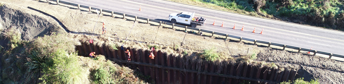
The 30-metre-long and 6.9-metre-high sheetpile wall was damaged in Cyclone Gabrielle, leaving the edges and the toe (the bottom front part) of the wall worn away and potentially weakened. A drain running along the wall was also damaged and needed to be replaced to direct rainwater and prevent flooding.
The repair work involved clearing plants and debris, rebuilding the worn ends of the wall, adding erosion control mats, trimming overgrown plants, and fixing the drainage system. The slope was stabilised using hydroseeding which helps control dust, erosion, and sediment runoff.

At this damaged site, repairs stabilised the bank slopes to protect the twin culvert bank. They included removing the damaged retaining walls and clearing vegetation to access the site, and trimming vegetation in some areas of the bank slopes to help with future water flow.
New retaining walls above the culvert have restored this section of the state highway, providing crucial support and protection for the road surface.

This image is from December 2024 when work was nearly complete with the rock-filled, gabion baskets supporting the wall of the bank preventing scour installed.
TREC has delivered safety improvements for NZTA alongside cyclone recovery work. Learn more about the safety improvements here:
SH5 Napier to Taupō safety improvements
CloseThe original Tarawera Culvert was significantly damaged in the cyclone spilling debris across the road and scouring alongside the road shoulder. An emergency culvert was installed just north of the original culvert with shotcrete (sprayed liquid concrete) applied to the inlet banks to help prevent erosion.
However, the 20mheight difference from the culvert outlet down to the riverbed has resulted in extensive scour (erosion). This will be repaired in 2025 to more effectively manage the water flow in and around the culvert and help protect the longevity of the road surface.
CloseThis site is 40km northwest of Napier where the Pokopoko stream runs through the steeply cut gully. During the cyclone this site had three underslips. Repairs are scheduled to start in late February 2025.