State Highway 2 (SH2) north of Devil’s Elbow suffered significant damage during Cyclone Gabrielle. The Transport Rebuild East Coast (TREC) Alliance is delivering recovery work to restore these highways.
This recovery area spans from SH2 north of Napier through to Mōrere. It includes Waikare Bridge which was destroyed during Cyclone Gabrielle, and the notorious Devil’s Elbow section of the state highway that was severely damaged.
There are multiple recovery sites, which include a mix of repairs to underslips, erosion, scour, bridges and culverts.
Below are some highlights of our work, and some typical sites that have similar challenges with the terrain. For a full list and map of all the projects, see our TREC GIS map.
Devil’s Elbow is the well-known local name for an extremely tight hairpin section of SH2 between Napier and Tūtira. This hilly and winding section is a key route for commuters, and people and goods moving through the region and there is no viable detour route.
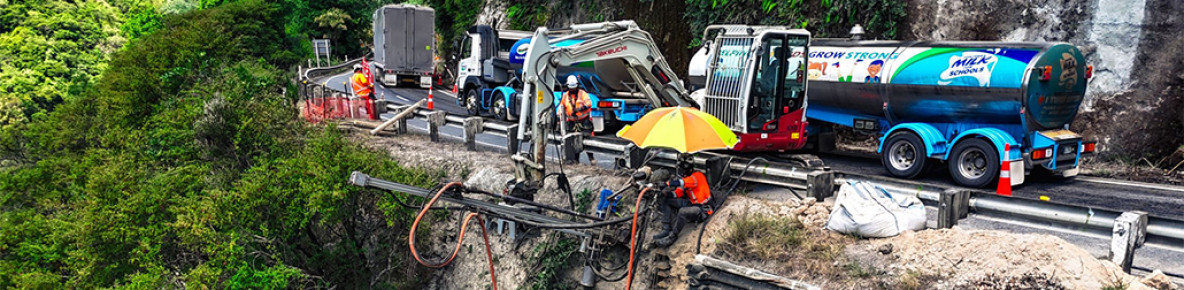
Critical to the connection of people living and using SH2 was the reconnection of the state highway with the installation and opening of the Waikare Bailey Bridge, and the demolition of the original bridge that had been snapped in half with the force of the water during the cyclone. Watch the video below to see demolition and clean up needed to recover this section, with a semi-permanent solution.
We also completed work through the Waikare Gorge descent on the north side of the gorge with an anchored retaining wall. The slope instability in this area is well known, and in July 2024 we responded to rock fall and undertook critical rock scaling under emergency closures.

SH2 emergency works at Waikare Gorge clear up a rock slip above the road and ensure the rock face is safe for road users.
Also in this section are several recovery sites through Mohaka where we repaired five underslips and replaced the bridge deck at Mangaturanga Bridge.
The extremely steep terrain on the bank beside the Mohaka River on SH2 (10 minutes north of Kotemaori) made this a difficult site to repair. A steep drop was 9 metres deep from the road level, so it was a challenge to get the heavy machinery in the right position to make repairs.
Excess water from a damaged culvert meant the road surface had started to crack and an underslip had developed. To reduce further deterioration to the underslip and road, the water was temporarily diverted while we repaired the slip and culvert.
Repairs have made this section more resilient to heavy rain.

YouTube video - SH2 Mohaka Coach Road underslip(external link)
CloseIn construction through autumn and winter 2025 are repairs at the Mohaka rail viaduct. On this steep underslip site the guard rail has begun to fall away and the road is down to a single lane . We’ll stablise the underslip using micropile and ground anchors and repair the road edge with a new concrete beam for a road barrier.

SH2 Mohaka Viaduct underslip recovery site is steep and narrow, challenging working conditions
There has been recovery work underway on many other sites (excluding Devil’s Elbow) between Pūtōrino and Napier. The vast majority of these are complete, with two more sites coming into construction in mid 2025.
Just north of Tutira are two retaining walls sites at Sandy Creek. One of these is under construction and the other is complete. At the completed site (featured below) a sheet piling retaining wall was installed to address underslip damage caused by Cyclone Gabrielle. Sheet piling involves using a large hammer on a crane to drive metal sheets 12 metres into the ground to stabilise it.

YouTube video - SH2 Sandy Creek retaining wall repairs(external link)
CloseThe White Pine Bush section has typically steep and challenging conditions. Recovery sites have included the repair of a 24m slip, and another slip that was 23m long and 5m tall.
The one featured below one was only 1.5m from the edge line making the work conditions tight.There was also scour (erosion) within the shoulder which extended a further approximately 17m north of the underslip.
We repaired the underslip with three rows of soil nails and shotcreted the affected area for further protection. The toe (or bottom of the underslip) had riprap (large rocks) installed to provide further protection against scour.

SH2 White Pine recovery working from ropes in the steep conditions
It doesn’t get much tighter than the worksite at Tangoio Falls Reserve, with trucks passing within 1 metre of the TREC crew member working on the digger. Below is an incredible side-on look at the worksite when it was under construction.
The team installed 100 ground anchors, each between 4 and 10 metres long, with a specialist team finishing the drilling. Ground anchors help stabilise slopes. This way of working allowed us to keep a lane open during construction, reducing the effect on people's travel times.
When the team had tested the anchors, they were sprayed over with shotcrete (liquid concrete). This was one of our trickiest recovery jobs because the site was steep, narrow, and difficult to access.

SH2 repair at Tangoio narrow and challenging working conditions for TREC crew
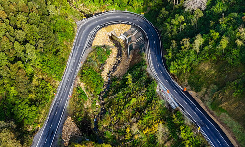
On SH2 north of Wairoa to Mōrere there are seven sites with a cluster of 4 of these through the Mōrere hill section. All of these sites were focused on drainage and are now completed.
One of the biggest challenges is the geology of Mōrere Hill. On the upper side of the state highway is a wetland, pushing the land under the road down the hill. The ground is soft, unstable, still moving and full of water.
At the Mōrere Hill landslide we designed a solution that will reduce water levels here with 13 counterfort drains, these have a total of more than 500m length.
You can see the extensive new drainage below. This work will help move water away, which will reduce water pressure building up in the hills and help reduce movement in the road.

SH2 at Morere recovery includes drainage work to mitigate the shifting ground.