The NZ Transport Agency warns all South Island alpine area drivers to be ready for winter conditions tonight and this weekend.
More snow is forecast this evening and tomorrow for the Lewis and Arthur’s Passes (State Highways 7 and 73).
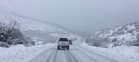
Chains are currently necessary on the Arthur’s Pass route. The Lewis Pass route could close at short notice due to ice and snow.
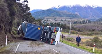
Delays can also occur unexpectedly as they did between 10.30am this morning and 2.30pm this afternoon when a truck rolled near Hanmer Springs turnoff, 5 km south of Boyle River, stopping all truck traffic. Other vehicles were able to get through. There may be continuing delays at this site for some time until it is fully cleared.

“With snow forecast to continue through the weekend, people need to check our traffic(external link) and travel pages for updates before they leave as well as the Met Service forecast. We may get a rerun of Thursday night’s snow again tonight with little change forecast for all day Saturday,” says Transport Agency Journey Manager Tresca Forrester.
Update on Lewis Pass (external link)
The other main route between the West Coast and Canterbury, Arthur’s Pass, SH73,(external link) requires chains (see below taken today) and no towing vehicles are currently allowed.

Drivers who are able to postpone their journeys through the Lewis Pass this weekend are advised to do so.
Traffic camera images (external link)
This highway is closed from Hollyford Valley Road due to snow. Please check our traffic and travel pages(external link) for updates:
Issued at: 11:04am Friday 8 Sep 2017 Valid until: 10:00pm Friday 8 Sep 2017
Snow showers are expected this evening and on Saturday. Between 5pm and midnight today (Friday), 1 to 2cm of snow may accumulate near the summit. From midnight tonight to midnight Saturday, 2 to 5cm may accumulate on the road above 800 metres, with lesser amounts to 600 metres. Note, further snow showers are possible on Sunday.
Issued at: 11:04am Friday 8 Sep 2017 Valid until: 10:00pm Friday 8 Sep 2017
A period of snow is expected this afternoon and evening. From 3pm to midnight Friday, 1 to 2cm of snow may accumulate on the road near the summit, with lesser amounts down to 700 metres. Another period of snow is expected on Saturday,from 1am to 3pm Saturday, 2 to 5cm may accumulate on the road above 700 metres, with lesser amounts to 500 metres.
Issued at: 11:04am Friday 8 Sep 2017 Valid until: 10:00pm Friday 8 Sep 2017
Snow showers are expected from this evening through to Saturday evening, from 7pm Friday to 8pm Saturday, 25 to 35cm may accumulate on the road near the summit, with lesser amount down to 300 metres.
Issued at: 11:04am Friday 8 Sep 2017 Valid until: 10:00pm Friday 8 Sep 2017
A period of snow is expected today, from midday to 6pm Friday, 1 to 2cm may accumulate on the road above 700 metres. Another period of snow is expected on Saturday, from 1am to 7pm Saturday 3 to 5cm of snow may accumulate on the road above 700 metres, with lesser amounts down to 500 metres.
Issued at: 11:04am Friday 8 Sep 2017 Valid until: 10:00pm Friday 8 Sep 2017
A period of snow is expected from this afternoon through to Saturday evening, from 1pm Friday to 9pm Saturday, 3 to 5cm may accumulate on the road above 700 metres, with lesser amounts to 400 metres. Note, further snow showers are possible on Sunday.
Issued at: 11:04am Friday 8 Sep 2017 Valid until: 10:00pm Friday 8 Sep 2017
Snow showers are forecast through to Saturday night, from 11am Friday to midnight Saturday, 90cm to 120cm (70 to 90cm for Saturday) of snow may accumulate on the road above 700 metres, with lesser amounts down to 400 metres. Snow level should lower to 200 metres overnight tonight, then rise to above 400 or 500 metres Saturday afternoon.