| Auckland region | New Zealand | Region as % of NZ |
|
|---|---|---|---|
| Population | 1,432,200 | 4,268,500 | 34 |
| Land area (km2) | 5600 | 275,400 | 2 |
| Imports (gross tonne)1, 2 | 14.1 million | 79.2 million | 18 |
| Exports (gross tonne)1, 2 | 8.3 million | 73.4 million | 11 |
| Gross domestic product (GDP) ($) | 42,200 million | 155,400 million | 27 |
| Passenger transport – bus – boardings | 43,165,200 | 92,777,200 | 47 |
| Passenger transport – rail – boardings | 6,794,100 | 18,346,600 | 37 |
| Passenger transport – ferry – boardings | 4,374,600 | 4,695,000 | 93 |
| Vehicle kilometres travelled | 12,200 million | 40,200 million | 30 |
| Fatalities3 | 81 | 366 | 15 |
| Serious injuries3 | 654 | 2553 | 19 |
| Local roads – urban all (km) | 4167 | 17,298 | 24 |
| Local roads – urban sealed (km) | 4149 | 16,956 | 24 |
| Local roads – rural all (km) | 3659 | 65,601 | 6 |
| Local roads – rural sealed (km) | 2577 | 33,698 | 8 |
| State highways – all (km) | 335 | 10,906 | 3 |
| State highways – sealed (km) | 335 | 10,850 | 3 |
| State highways – motorway (km) | 106 | 172 | 62 |
This NLTP includes a new government initiative: a programme for seven of New Zealand's roads of national significance. The programme aims to reduce congestion, enhance safety and support economic growth.
The roads of national significance on which investment will be focused to achieve economic growth and productivity in Auckland are:
The SH20/SH16/SH18 Western Ring Route is the motorway connecting Manukau, Auckland, Waitakere and North Shore cities. On completion, it will take traffic from Manukau through Waterview and Hobsonville to Albany. In doing so, it will connect major growth areas in the south, west and north of the region and provide a strategic alternative to SH1 by bypassing the Auckland Harbour Bridge.
Two key components being delivered ahead of the Rugby World Cup are the SH1 to SH20 Manukau extension to link these two motorways, and the SH20 Manukau Harbour crossing to increase Mangere Bridge to eight lanes plus bus shoulder lanes by early 2011.
By 2012, the Hobsonville and Brigham Creek sections of the route will be completed, resulting in reduced congestion and improved safety.
The government has provided greater certainty for the SH20 Waterview connection – the final section of the Western Ring Route that will connect SH16 and SH20. The NZTA Board has selected a preferred route option and the project is moving towards designation. Provision has been made for widening and upgrading interchanges on SH16 to balance capacity between the new and old sections.
The five-year Victoria Park Tunnel project to improve capacity and unlock this bottleneck south of Auckland Harbour Bridge starts later this year.
A new three-lane northbound tunnel will be built alongside Victoria Park Viaduct and the existing structure will be used to provide four southbound lanes. Another lane will be added in both directions between the viaduct and the Harbour Bridge, giving 10 lanes in total, plus a southbound bus lane along St Marys Bay. Provision will be included for a northbound bus lane in the future.
The Puhoi to Wellsford project follows the success of the Northern Gateway Toll Road. Route planning, with the NZTA working with stakeholders and the community, is expected to take up to five years.
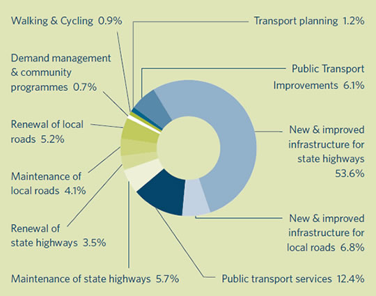
| Auckland | 2009/12 | % of total |
|---|---|---|
| Walking and cycling | 24.6 | 0.9% |
| Transport planning | 32.6 | 1.2% |
| Public transport improvements | 172.1 | 6.1% |
| New & improved infrastructure for state highways | 1,501.8 | 53.6% |
| New & improved infrastructure for local roads | 189.4 | 6.8% |
| Public transport services | 346.5 | 12.4% |
| Maintenance of state highways | 159.4 | 5.7% |
| Renewal of state highways | 96.7 | 3.5% |
| Maintenance of local roads | 113.7 | 4.1% |
| Renewal of local roads | 144.5 | 5.2% |
| Demand management & community programmes | 21.0 | 0.7% |
| 2,802.2 | 100% |
Note: includes R funds of $570m, C funds of $107m
Auckland has a large proportion of high-priority state highway projects and is benefiting from a nationwide 30 percent funding increase in this category, compared with 2006–2009. This increase represents $1 billion more in investment than the previous three years.
The funding focuses on the roads of national significance and roads that are critical to enabling roads of national significance. It also funds work on other key routes that improve freight and tourism and make a major contribution to economic growth and productivity.
In Auckland, improvements are scheduled region-wide, with a particular emphasis on the Western Ring Route and airport. Outside the Auckland metropolitan urban limit, improvements include upgrading existing two-lane highways, seal widening and creating passing lanes. Projects that are likely to be funded include:
Investigations into protecting the route of an extended Northern Busway from Constellation Drive to Orewa will also increase state highway capacity long-term, with provision in the meantime for buses on improved motorway shoulders. New state highway projects are being developed in consultation with ARTA to ensure provision for public transport.
State highway maintenance will focus on making the best use of existing infrastructure to extract maximum value for money, and extending the life of the asset base through timely and well planned interventions.
Maintenance for these roads includes repairs and upgrades to carriageways, bridges including the Auckland Harbour Bridge, drainage, road marking, signs and traffic signals. It also includes incident response, litter and graffiti removal and vegetation control. One of Auckland's most significant assets, the Auckland Harbour Bridge is currently undergoing major improvements to strengthen the box girders. This work is scheduled to be completed in 2010.
Timely maintenance avoids delays caused by unplanned closures and improves network safety and resilience. Unplanned incidents, even minor crashes, impose significant costs and threats to productivity, so the NZTA is improving safety and incident response times across the network. The NZTA will continue to install fencing to minimise the incidence of objects being thrown from overbridges, manage over height bridge strikes and deter graffiti.
A focus for Auckland over the period of this plan is to maximise network efficiency, providing safer travel, ensuring better journey time reliability and optimising throughput leading to efficiency gains in terms access to markets, areas of employment and economic growth.
At the operational level, the NZTA manages congestion and safety using technology such as traffic signal phasing, lane signal controls, variable message signs and web-based information systems. Providing road users with quality information on traffic conditions enables them to make informed choices, while on-road information helps to clear delays and prevent further accidents and congestion.
Auckland Traffic Management Unit is due to be relocated in 2009 and will be expanded toincorporate a National Traffic Management Centre.
Since 2006, the NZTA has been installing ramp signals at motorway on-ramps around Auckland. By the end of 2009, all motorways will have signals to provide better traffic flow, safer merging and more reliable trip times.
Local road improvements in Auckland will focus on projects that deliver the greatest economic and productivity benefits for local roads that have a critical support role in the operation of roads of national significance and key urban arterial routes.
As part of our commitment to extracting maximum value from past and current investments, the NZTA will fund capacity improvements on high-volume roads before considering expenditure on new infrastructure.
The local road infrastructure funding matches the delivery patterns of the previous three-year period. Significant projects, and their estimated project costs, that are likely to be funded include:
The NLTP allocates increased funding to maintain the region's local road network over the next three years. The pavement rehabilitation and renewals programme is the key driver for this increase.
The Auckland programme has been negotiated with approved organisations to prioritise spending based on the best use of existing infrastructure. Particular focus is placed on key routes; for instance those that provide access to markets or areas of employment or economic growth. The NZTA has approved a three-year allocation and expects organisations to manage the required maintenance, operations and renewal programmes including any changes in costs within that allocation.
The programme's contribution towards network security, resilience and safety has also been carefully scrutinised. A robust system to manage existing infrastructure has been adopted that reflects the findings of reviews of asset management practices.
There is considerable variation in the standard of the road network throughout the region when it is compared with national indicators. Some parts of the network are above or on par with these indicators, whilst some are below. The programme aims to deliver a more consistent standard across the region in the years ahead.
The NZTA is investing heavily in public transport infrastructure in the region, including providing a loan for the purchase of rail rolling stock. Public transport projects given the highest priority are those that:
While rail development remains a priority, it lies largely outside this programme and will be led by other agencies. Below track rail infrastructure such as the track, signals and platforms is funded by Crown.
Major activities likely to proceed, with their estimated costs, include:
There is a substantial 30 percent increase in funding for public transport services nationally in 2009–2012 to $630 million compared with the previous three-year period.
There is also an allowance for small increases in operating costs in the first year of the programme. Beyond the first year, approved organisations¹ will need to manage costs within existing allocations.
As with public transport infrastructure, the emphasis is on services that will ease congestion in major urban areas and deliver the greatest return on investment. Projects given the highest priority will be those that increase farebox recovery rates² and maximise the use of existing services. The NZTA is developing a national farebox policy to assist regional authorities in this area.
The block funding approach to public transport programmes will provide regional authorities with flexibility to reassign funding to cover variability in the delivery of activities, provided total expenditure stays within the allocation.
As part of the $630 million national allocation, $18 million has been included for new service starts. To obtain funding for any category 2 new service starts, initiatives will be assessed against the NZTA investment priorities and will have to meet the meet strategic fit, effectiveness and efficiency standards.
The major investment in public transport in Auckland will be in rail capital and supporting operational funding over the next three years. As part of this, ARTA requires additional funding to its base programme to support the running costs associated with an expanded rail rolling stock fleet.
ARTA is also looking at additional funding for ferry stations and renewal initiatives, ferry maintenance and some IT initiatives. Funding for these proposals may be possible depending on how they align with the Investment and Revenue Strategy at time of application for category 1 funding approval.
¹ An 'approved organisation' is a public organisation approved under section 23 of the Land Transport Management Act 2003. It's usually a regional council, a local authority or another public organisation.
² In farebox recovery, a proportion of total operating costs is recovered through fare revenue.
National funding for walking and cycling initiatives has increased substantially over the three years of this NLTP compared with the previous three years.
In Auckland this is likely to fund larger and more tightly focused projects in urban areas that reduce congestion by providing viable alternatives to the private car. Historically, funding in this activity class has tended to focus on smaller, more regionally dispersed projects.
Key links will be completed on existing projects. Projects already committed (approximately $25.7 million) will be progressed and new projects started where they fit new assessment criteria. Projects include:
Transport planning funding is being maintained at the levels of the previous three-year period. This NLTP prioritises planning for roads of national significance, freight and tourism routes and areas with fast-growing populations and employment. It encourages well focused, regionally coordinated studies that result in higher-priority projects.
The NZTA will continue best practice planning that:
Demand management and community programmes include the management and purchase of activities that provide safe and effective use of land transport networks.
This NLTP prioritises activities that deliver the greatest economic and/or safety impacts through:
The NLTP and the detailed 2009/10 Road Policing Programme can be viewed at the New Zealand Police website www.police.govt.nz(external link) and programmes for 2010/11 and 2011/12 will be published annually on the site.
³ This is currently the Road Safety to 2010 Strategy. The Road Safety to 2020 Strategy is under development.
Post 2012/13, the Auckland region will continue to focus on strategies and activities that provide value for money and contribute to economic growth and productivity, as well as improve safety and increase transport choice.
Those planned to start in the seven years beyond 2011/12 (or where construction continues into this period), include:
Last updated: 6 October 2009