Making Brougham Street better will mean everyone can get along and across Brougham Street safely. Freight can get where it’s needed, to keep our economy thriving and people will have more travel choices that will work better for them and the environment.
We have an opportunity to redesign one of Christchurch’s busiest roads, making it safer and easier for people to do everyday things like taking children to school, travelling to work or the shops, moving goods and doing business.
The changes we’re recommending on State Highway 76 Brougham Street make use of the existing road space to move more people, more safely. They’re simple but effective changes that will provide people with different and safer ways to travel.
We want to move people, not more cars. We want to encourage more people to walk, cycle, carpool or take a bus, creating great outcomes for communities, our economy and our environment.

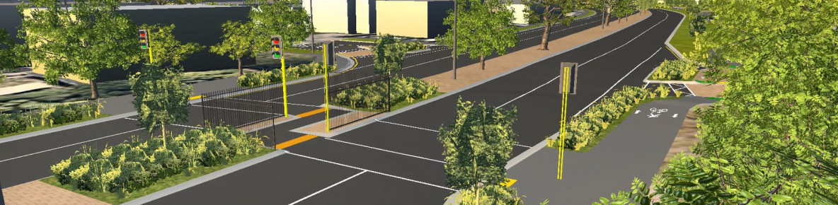
When you are walking along Brougham Street you can use the existing footpath on the north side of the street, or the proposed shared path along the southern side of the street anywhere between Opawa Road and Simeon Street. Getting across intersections will be safer and easier, with improved signalised crossings at all intersections and new signalised crossings at Montreal Street, Gasson Street and near Wilsons Road. Changes to vehicle access on some streets will reduce the number of cars turning across your path. You’ll be able to use raised pedestrian crossings in some places or you can avoid traffic completely by using the new overbridge.
When you are cycling or scooting you can use the new shared path alongside those walking, with all the same safety benefits while travelling through intersections (see above). This shared path is also a great way for you to connect with existing Major Cycle Routes in the area, such as the Little River Link west of Simeon Street and the Quarryman’s Trail on Antigua Street. There will be dedicated space for cyclists at intersections and new painted cycle lanes to connect into existing Major Cycle Routes in the area.
If you’re catching the bus your driver will be able to beat some of the morning and evening congestion by using the new T2 lanes, providing more reliable travel times. Upgraded traffic signals at the intersections of Colombo and Selwyn Street let buses go ahead of other vehicles too.
When you are driving along Brougham Street and there’s two or more people in the vehicle you’ll be able to save yourself some time by driving in a T2 lane. If you’re a passenger, you also get to enjoy a bit of down time! You will be sharing this lane with buses, and people on motorcycles.
You will not be able to use the T2 lane if you are by yourself, but you will still benefit from reduced traffic. Every car you see in the T2 lane means two fewer cars in your lane. New right-turn signals at major intersections will make it safer and easier for you to turn off or onto Brougham Street and get where you’re going. There will be some changes to vehicle access that may take some adjusting to, with ‘no turn’ signs added on certain side streets, and on-street parking available only during off-peak hours to allow for the T2 lane during peak times.
If you’re riding your motorbike along Brougham Street you will experience most of the same changes as other vehicles on the road (see above), with one exception. You will be able to drive in the T2 lane during peak times, even if you don’t have a passenger.
If you drive a truck, you’ll notice a difference at the traffic lights. The changes we’re making will see traffic signals optimized at peak times to make it easier to get to and from important places, like the Port.

Because it’s important to us that the proposed cycling and walking overbridge between Collins Street and Simeon Street works for the community who will be using it, we invited members of the local community groups and people who cross Brougham Street to participate in a Bridge Feedback Group (BFG) to share their ideas, aspirations, and feedback about the proposed pedestrian/cycle overbridge. The Bridge Feedback Group includes mana whenua and people from organisations who represent older community members, cyclists, schools, those who are differently abled and heritage and community groups.
To help make sure the bridge is right, we have been meeting with this group to discuss and test our concepts. We have discussed safety, lighting and accessibility, landscaping, storytelling and design. In June 2023 we asked this group and other volunteers from the community to take part in some virtual walkthrough sessions.
A virtual walkthrough model was developed to help us share a skeleton of the bridge concept with session participants. The groups were able to ‘walk or ride’ through the model and give their insights of how they felt the bridge would function both during the day and at night.
We have made this short video below to show the model in action so everyone can see it. Please note the bridge shown in the video is purely a skeleton concept to give participants an idea of what it would feel like to walk or cycle over and does not reflect the final design of the overbridge. The design work will come next.
Insights from both the Bridge Feedback Group sessions and the virtual walkthrough are helping our design team ensure the bridge is user friendly and nice to look at.
Close