Safe, reliable and resilient access to remote communities and farming, forestry and tourism, is important to encourage economic growth and prosperity in the Otago and Southland regions.
Investment through this National Land Transport Programme (NLTP) recognises the importance of a regional land transport system that is safe, well-connected and resilient to get goods to market and to maintain the growth in tourism.
In urban areas, investments will encourage a shift from the use of private vehicles towards public transport and active options, eg walking and cycling as travel choices. The shift will support health outcomes for people at risk from obesity, heart disease and diabetes, and contribute towards Government initiatives for a cleaner environment.
This investment will also provide safe and improved access to schools, employment and goods and services that have great social and economic benefits, as well as contributing to creating a liveable urban environment that attracts more people to live, work and study in Otago/Southland.
Ensuring greater value for money from transport investments made in Otago and Southland is also a priority.
The Transport Agency will work with its key partners in local government, the tourism and farming sectors and with other stakeholders to deliver its key objectives.
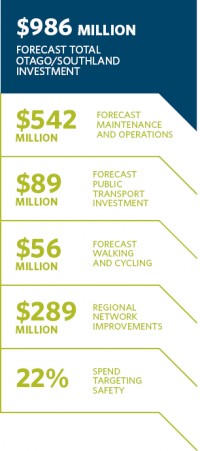
During the 2018-21 NLTP period, $342 million has been allocated for local roads, and $200 million for state highway maintenance and renewals in Otago and Southland.
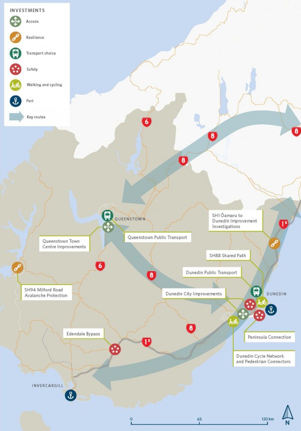
Connecting Dunedin will continue to coordinate the delivery of Dunedin’s transport system. This partnership between the Dunedin City Council, Otago Regional Council and the Transport Agency will ensure the city is well placed to respond to changing mobility demands from people, and provide safer and better integrated public transport, and walking and cycling networks.
The Dunedin bus hub, a joint Otago Regional Council and Transport Agency project in the city’s CBD, is expected to open in November 2018. The one service point in the central city will provide better connectivity and make it easier for people, particularly for those who are less frequent passengers on public transport, to use buses as a travel option. The location of the bus hub to the site of the new Dunedin Hospital will also help with accessibility and reducing traffic.
The $7 million one-way system separated cycle lanes project through central Dunedin will also be completed late in 2018. This project will increase safety for cyclists and other users of this busy route. It will complement the rest of the Dunedin transport system and help grow cycle connections in the central city.
For example, cycling will be supported by further work on the Dunedin City Council’s Central City Cycle Network project that includes a cycle bridge over Water of Leith, and connecting with the SH88 shared path to Port Chalmers. The project also provides a route through the industrial area to Portsmouth Drive and via the rail corridor to Anzac Avenue in front of Dunedin's rail station. The $7.8 million project, jointly funded by the Transport Agency, is designed to improve access and safety for cyclists. A new harbour cycle and pedestrian connection is planned to link Queens Gardens and the Harbourside area, improving accessibility to and from the central city. It will be a catalyst for future development.
Construction will continue on the next stages of the Dunedin City Council’s Portobello Road improvements. This Peninsula Connection project widens the road from Vauxhall to Portobello, improving safety and delivering a shared path for cyclists and walkers. Low-lying sections of the road will be raised to protect against rising sea levels.
The roll-out of all-direction pedestrian crossings at several CBD intersections will be completed during this NLTP. The project is jointly funded by Dunedin City Council and the Transport Agency. The crossings increase safety in the inner city. The risk of fatal and serious injuries to pedestrians is higher in Dunedin than in other cities of a similar size. Safety and accessibility projects are also planned for the central business district and tertiary precinct.
Significant progress will be made to complete improvements on SH88 between Dunedin and Port Chalmers. This includes highway safety improvements and the final five-kilometre-long section of the separated shared path for walkers and cyclists. Work on the shared path will start in 2019 and take three years.
The Transport Agency is taking a multi-agency approach to manage transport opportunities and growth challenges in Queenstown, reflecting the town’s rapid expansion as a holiday destination and lifestyle choice.
Investigations are looking at various transport improvements within the town centre, to meet projected increases in the population and visitors. Consideration is being given to activities that will improve access and public transport efficiency, such as bus priority measures; a new public transport hub; pedestrianisation of the town centre; new on-road/off-road shared walking/cycling opportunities; and a range of public transport improvements, including water ferry services where feasible.
The Transport Agency and local transport partners – Queenstown Lakes District Council, Otago Regional Council and Queenstown Airport Corporation – are working together to better align land use and transport planning, and looking at how to develop and deliver transport options that support land use development and reduce reliance on private vehicles.
Queenstown’s tourist economy will be supported through rock fall protection work at nearby Nevis Bluff on SH6 to reduce the risk of closure of this vital tourism corridor.
The Transport Agency, together with its partners, will improve safety for all road users, including visiting drivers, in Otago and Southland.
Upgrades include installing wide centrelines and audio tactile pavement markings (rumble strips), corner chevron signage, wire rope barriers and pull-off areas, building on recent investment to improve safety.
On SH1 between Ōamaru and Dunedin planning work will continue on a major programme of safety measures including the installation of roadside barriers and wider centre lines to help prevent head-on crashes. Between 2007 and 2016, 30 people died and 112 were seriously injured in crashes on this section of highway.
In the Catlins coastal area east of Invercargill, the Haldane-Curio Bay Road safety improvements are being completed. The upgrade has the potential to unlock more of the area’s tourism potential, creating new business and job opportunities. The $7 million project is jointly funded by the Southland District Council and the Transport Agency. Work includes sealing a busy gravel road, and better access to visitor attractions along a route popular with tourists. Historically, this narrow gravel road has had a high crash rate involving visitor drivers.
Climate change is affecting the resilience of the region’s land transport system as a freight corridor and reliable connectivity of its communities. Coastal erosion along SH1 at Katiki Beach between Palmerston and Ōamaru is being monitored and a long-term solution is being developed. Improvements to protect sections of SH1 prone to flooding and erosion between the Waitaki River and Dunedin are also being developed.
The Milford Rockfall/Avalanche Protection programme will investigate improved ways to reduce the risk of closure from rockfalls and avalanches on SH94 between Te Anau and Milford Sound, one of New Zealand’s premier tourist corridors. Investigations include relocating the existing visitor stopping area on the eastern side of the Homer Tunnel and the installation of high velocity catch fencing.
Greater use will be made of digital technology to provide people with up-to-date travel information to enable people to better plan safe and reliable journeys.
Work is accelerating to replace existing Otago/Southland local authority and state highway lighting with LED lights, which are better value for money and deliver positive environmental outcomes.
The realignment of SH1 at Edendale in Southland is scheduled to open in 2020. The project will provide a safer and healthier environment for residents of the township by reducing highway traffic noise and vehicle emissions, and improving access for the community.
Investigations will continue during the next three years into Otago’s public transport networks. These will focus on opportunities to expand the network, increase capacity and the frequency of services, and the use of new technology to make public transport a more attractive travel option. This, along with the investment in walking and cycling networks and travel behaviour change programmes, will provide safe and convenient alternatives to motor vehicles as travel choices in Dunedin and the high growth area of Queenstown Lakes area.