Safer and more resilient routes to cater for the growth in freight volumes and increasing tourist numbers remain the two biggest drivers for investment in the transport system throughout Canterbury.
As the region produces 57% of the South Island’s GDP and is the main freight distribution centre for the south, freight is a significant source of road and rail traffic through the region. Freight carriers share the road network with a growing number of tourists who travel quite differently. While freight journeys are often time critical, tourists are less constrained, taking time to stop multiple times along the way. The region’s network needs to cater for both types of journey.
Better access remains the greatest issue for Greater Christchurch as the city and neighbouring districts of Waimakariri and Selwyn continue to adjust to the change in growth patterns following the earthquakes earlier this decade.
During the next three years, transport investment in Greater Christchurch will be focused on:
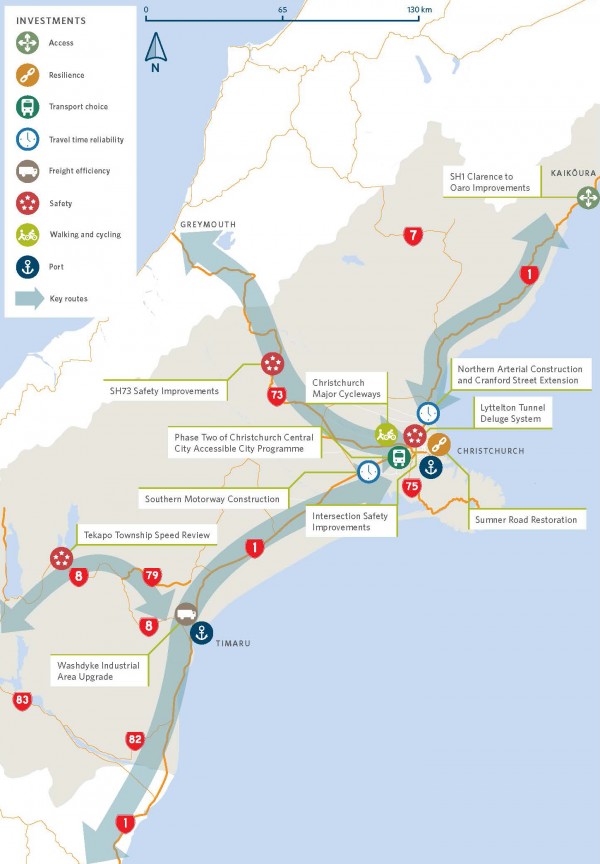
Further north, investment in both the Kaikōura and Hurunui districts will remain focused on earthquake recovery and completing the rebuild of the state highway and the local road network.
Stage two of the southern motorway – four-laning of SH1 from Rolleston through to Christchurch – is expected to be completed in early 2020. The Northern Corridor connecting the Waimakariri River through to QE11 Drive and Cranford Street is on schedule to be completed in 2019/20.
These two motorways will complete the Christchurch Motorways project, providing for safer travel to the north and south of the city (the first of the major state highway corridor upgrades - the Western Corridor - was completed in November 2017). These three corridors provide better access for freight to and from the Christchurch International Airport, the Lyttelton Port of Christchurch and also to and from freight hubs in the southwest of the city, supporting economic growth of not only Canterbury but the wider South Island.
Encouraging heavy traffic away from suburban Christchurch streets will help make these communities safer for walking and cycling, and provide more efficient public transport services with improved travel times.
To the west of Christchurch, on SH73 to the West Coast, the realignment of Mingha Bluff in Arthur’s Pass National Park is nearing completion, providing safer and improved access for freight between Canterbury and the West Coast.
State highways 1, 73 and 75 have been identified as key corridors where there are a number of opportunities to implement a range of safety improvements. SH1, in particular carries high volumes of freight and tourists. The Transport Agency is planning a package of safety improvements along the highway, in particular from the Ashley River through to Belfast and from Ashburton south of the Rangitata River.
Safety improvements are also planned for SH73, which is under increasing pressure from growth to the west of Christchurch.
The new southern motorway will provide better access from the south through to Brougham Street (SH76), halving travel times from Rolleston through to Christchurch’s central city and reducing deaths and serious injuries along SH1. As the main freight route from the inland ports at Rolleston, as well as the southwest industrial hubs through to Lyttelton Port, SH76 goes through a mix of residential suburban streets, retail hubs and semi-industrial estates. In 2018-21, work will continue on the detailed business case to look at how to make this route safer and more efficient to cater for the increased traffic volumes and also create safer walking and cycling opportunities for the local community and wider network south of Moorhouse Avenue.
Both safety and access to the Lyttelton Port of Christchurch will be improved with:
These two projects will also build greater resilience into the connections between Christchurch and Lyttelton Port, critical for both fuel supplies for the South Island and access to export markets.
In Christchurch, the city plans to target improving the safety at the highest risk intersections as identified in the KiwiRAP top 100 list.
During this NLTP, work will progress on the detailed business case to build a second bridge across the Ashburton River, and improvements to the corridor through neighbouring Tinwald.
Resilience and safety improvements are planned for Thompsons Track, including road widening and resealing. Three bridges over the Rangitata Diversion will be upgraded to unlock HPMV access on local roads in the area.
Further south, a number of bridges on key freight routes in Timaru will be upgraded to improve HPMV access, as well as realigning the Seadown and Meadows Roads intersection to both improve safety and provide better access to the industrial zones at Washdyke.
In Tekapo, work will begin on implementing the tourist town’s Transportation Strategy: improving walking and cycling facilities and traffic management.
In Greater Christchurch, the completion of the Christchurch Southern Motorway in 2020, requires a number of safety and access improvements within the Selwyn district. This work includes intersection upgrades in Prebbleton and Rolleston. In Rolleston, additional footpaths will be installed in the town centre as part of implementing the town’s walking and cycling strategy.
Building better connections to Rolleston’s industrial zone are planned to ensure reliable access between the inland ports and both Timaru and Lyttelton Ports.
Further co-investment is planned during the 2018-21 NLTP on Christchurch’s 13 major cycleways routes to help complete the safe, easy to use network of cycleways connecting the city’s suburbs to the central city and linking with local cycleways. About half the cycleways have now been built.
The Heathcote Expressway and Quarryman’s Trail will be completed early in this NLTP period, while work is expected to begin on both the Nor’West Arc and Southern Lights cycleways. Investigation and design work will continue on the South Express, Avon-Ōtākaro and Ōpāwaho River routes ready for construction to begin either towards the end of this three-year period or in 2021-24.
It is expected that $28 million will be invested in walking and cycling in Christchurch in the 2018-21 NLTP.
Work will continue in 2018-21 to look at the future expansion of the region’s public transport network, including growth in network capacity and the frequency of services, during the next 30 years. In particular, the focus will be on the routes to the north and southwest to manage growth in these areas, by providing cost-effective and efficient alternatives to private car use.
Capacity on the existing highway network will be quickly absorbed and those living to the north and south of Christchurch will need to consider how they move about and look to use alternative travel modes to the private car.
There are service improvements to the public transport network being progressed including:
In support of the network improvements, the Christchurch City Council will be looking to improve interchange hubs at Shirley and Eastgate key activity centres.
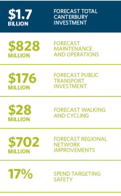
Keeping the land transport system well maintained and safe is a large part of the annual investment from the National Land Transport Fund in the Greater Christchurch area. This money ensures the transport system is safe, reliable and easy to use, helping to keep communities connected and supporting economic growth.
During the 2012-18 NLTP period, $426 million has been allocated for local roads and $402 million for state highway maintenance and renewals within the Greater Christchurch area. This represents a significant lift in maintenance for the transport network.
Canterbury remains committed to improving the environment, with all councils throughout the region planning to invest in additional LED lighting during this NLTP period. Christchurch city is planning to spend $25 million to complete the transition of the city’s streetlights to LED, recognising the significant cost and environmental benefits of LED lights.